Look at it closely. No, seriously, pull up a high-res image of the Attack on Titan map and tilt your head. Or better yet, just flip the image upside down and look in a mirror. It hits you instantly. The "continent" where the Marleyans live is just Africa, but inverted. Madagascar has been swapped for the Isle of Paradis. This isn't some lazy design choice by Hajime Isayama. It’s a deliberate, chilling subversion of our own geography that anchors the high-fantasy horror of Titans into a reality that feels uncomfortably familiar.
Most fans spend their time arguing about Eren’s motivations or the ethics of the Rumbling. But the geography? That’s where the real lore is hidden.
The world of Shingeki no Kyojin doesn't take place in a nebulous "middle earth." It takes place on an Earth that has been turned on its head. North is South. East is West. And for the people living inside the Walls, their entire "world" was actually just a tiny, isolated speck on the tip of a much larger, much more hostile planet.
The Secret Geometry of Paradis Island
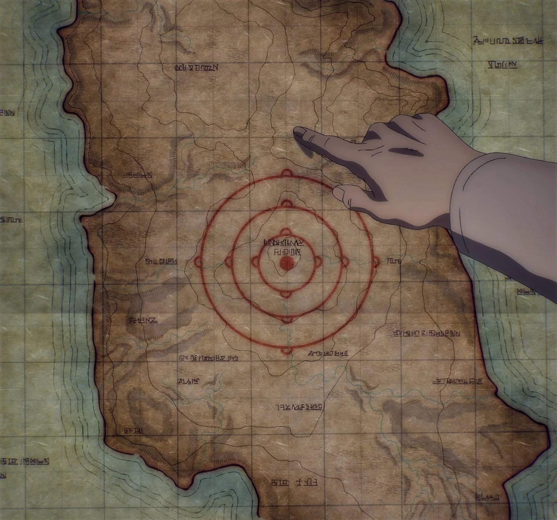
If you look at the Attack on Titan map from the perspective of the early seasons, you’re looking at three concentric circles: Wall Maria, Wall Rose, and Wall Sina. For years, we thought this was the whole world. Isayama tricked us. He used the "inkblot" style of fantasy map-making to make us feel as claustrophobic as the characters.
But here is the scale that messes people up.
The distance between Wall Maria and Wall Rose is about 100 kilometers. From Rose to Sina, it's 130 kilometers. Then you have the 250-kilometer radius of the inner territory. If you do the math—and plenty of dedicated fans on Reddit have spent hours on the geometry—the land area within the walls is roughly 723,000 square kilometers. That is massive. To put that in perspective, the "island" of Paradis is larger than the entire country of France.
When characters talk about "reclaiming the land," they aren't talking about a few fields. They are talking about a sub-continent. This scale is why the transition from Season 3 to Season 4 was such a gut-punch. We realized that this massive expanse of land was actually just a small island off the coast of a gargantuan continent.
Marley and the Inverted Earth
The revelation of the Marleyan map changed everything. It wasn’t just a plot twist; it was a geographical recontextualization. Marley occupies the landmass we know as Africa, Europe, and parts of the Middle East, just flipped.
Why do this?
Honestly, it seems like Isayama wanted to play with the idea of perspective. By using a "flipped" Earth, he creates a sense of "uncanny valley" geography. You recognize the shapes of the coastlines, but everything is "wrong." This mirrors the moral complexity of the show. Just when you think you understand the "map" of who is good and who is evil, the perspective shifts, and you realize you’ve been looking at the world upside down the whole time.
The Attack on Titan map also reveals the sheer logistical nightmare of the Rumbling. When Eren starts his march, he isn't just walking across a field. He is crossing a literal ocean. The distance between the southern tip of Marley (what we would call the northern coast of Africa) and the northern regions is thousands of miles. The sheer speed at which the Wall Titans moved suggests they weren't just walking; they were moving at the pace of a modern seafaring vessel, steamrolling everything in their path.
The Hizuru Connection and the Rest of the World
We rarely see the Far East in the series, but the map tells us it exists. The nation of Hizuru, where Mikasa’s ancestors originated, is essentially the "Japan" of this inverted world. If Marley is Africa/Europe, then Hizuru sits somewhere in the equivalent of the Orient.
There’s a lot of debate about the "Mid-East Allied Forces" too. We see them in the opening of Season 4. Their geography seems to correspond to the flipped Arabian Peninsula. This shows that the Attack on Titan map isn't just about Paradis vs. Marley. It’s a global geopolitical powder keg.
The world is huge.
Eren didn't just target a city. He targeted a globe.
Climate, Sun, and Navigation
Here’s a detail most people miss: the sun.
In the world of Attack on Titan, the sun rises in the west and sets in the east. Think about that for a second. In our world, the Earth rotates counter-clockwise. For the sun to rise in the west on the Attack on Titan map, the planet would have to be rotating in the opposite direction, or the poles are completely flipped.
This explains the climate.
Paradis is relatively temperate, much like Madagascar would be if it were shifted into a different climate zone. But the "South" of the Marleyan continent is where the ice and cold are found. When the Scouts finally reach the sea, they are looking at a body of water that represents the ultimate barrier, but also the ultimate connector.
The Logistics of the Three Walls
You can’t talk about the map without talking about the sheer impossibility of the Walls.
- Wall Maria: The outermost wall, 50 meters high.
- Wall Rose: The middle wall, where the refugees fled after Shiganshina fell.
- Wall Sina: The inner sanctum for the elite and the King.
Building these wasn't a feat of masonry; it was a feat of Titan hardening. The map shows us that Shiganshina, Trost, and Stohess aren't just random towns. They are "districts" that act as bait. By protruding from the main circular walls, they concentrate the Titans into specific areas, making defense easier.
It’s a brilliant bit of tactical geography.
The Attack on Titan map is designed for a siege. The entire island of Paradis was turned into a giant, open-air prison/fortress by King Fritz. When you look at the map from a bird's-eye view, the intentionality is terrifying. Every river, every forest (like the Forest of Giant Trees), and every mountain range was factored into how the Eldians would survive—or be trapped.
The Reality of the Sea
For 100 years, the people of the Walls didn't know the sea existed. They had "salt lakes" in their stories, but the actual ocean was a myth. When Armin and Eren finally stand on that beach at the end of Season 3, they are at the northernmost tip of Paradis.
Across that water lies the Marleyan port.
It’s a short trip by boat, but an impossible one by swimming. This narrow strait is what kept the "Devils of Paradis" isolated. The geography was their protector until technology caught up. Once Marley developed ironclad ships and Zeke’s "beast" could hurl rocks across distances, the map ceased to be a shield and became a target.
Why the Map Matters for the Ending
Without spoiling the nuances for the three people who haven't finished the series: the map is the scorecard.
As the Rumbling progresses, we see the "ink" of the Titans spreading across the Marleyan continent. The tragedy of the Attack on Titan map is that it shows us a world that was finally becoming globalized—through trade, through the Mid-East war, through the flight of the Hizuru—only to be systematically erased.
Isayama didn't just draw a map; he drew a graveyard.
The flipped geography serves to remind us that this could be us. It’s a "What If" scenario played out on a global scale. If our world was rearranged, if our borders were drawn by 50-meter-tall monsters, would we act any differently?
Probably not.
Actionable Insights for Fans and Researchers:
If you want to truly understand the spatial logic of the series, stop looking at the maps provided in the anime's "Information for Public Disclosure" segments in isolation.
- Download a map of the world and flip it vertically (upside down) and then horizontally (mirror image).
- Overlay the Paradis map onto the tip of "inverted Africa."
- Trace the path of the Rumbling starting from the northern tip of the island. You’ll realize that the Titans had to cross the equivalent of the Mozambique Channel before they even touched the main continent.
- Compare the wall diameters to real-world countries. Realizing that Wall Maria encompasses an area larger than many European nations changes how you view the "scarcity" of resources the characters complain about. It wasn't a lack of land; it was a lack of safety.
The map is more than just a guide to where the characters are. It is the physical manifestation of the show's themes: imprisonment, perspective, and the terrifying scale of human conflict. Next time you watch, pay attention to the compass. You’ll never look at a sunrise the same way again.