If you’ve ever driven east out of New Orleans toward Slidell, you’ve felt that sudden shift. The skyline of the Big Easy fades in the rearview, and suddenly, you’re suspended over the vast, shimmering gray-blue of Lake Pontchartrain. This is the Frank Davis "Naturally N’Awlins" Memorial Bridge, though literally nobody calls it that. To locals, it’s just the I-10 Twin Span Bridge.
Searching for i-10 twin span bridge photos usually starts as a quest for a pretty sunset shot, but it quickly turns into a history lesson you didn't ask for. You see these images of massive concrete slabs tossed into the water like discarded LEGO bricks. It’s haunting. Honestly, it's one of the most visceral visual reminders of what Hurricane Katrina actually did to the Gulf Coast's infrastructure.
But there’s a lot of confusion out there. People mix up the old bridge with the new one, or they think the fishing pier in Slidell is just a broken remnant that never got fixed. Let’s set the record straight on what you’re actually looking at when you scroll through those gallery feeds.
The Ghost Bridge: Why the Old Photos Look So Different
When you look at older I-10 twin span bridge photos, specifically from the late 90s or early 2000s, you’ll notice the bridge looks... well, kind of flimsy.
The original Twin Spans were finished in 1965. They sat just 8.5 feet above the water. For decades, they were the lifeline for commuters. Then August 29, 2005, happened. Hurricane Katrina didn’t just flood the city; its storm surge created a "piston effect." The rising water trapped air under those low-lying concrete spans, and the waves literally lifted 64 massive segments—each weighing about 255 tons—right off their concrete pilings and dumped them into the lake.
If you find photos of a bridge that looks like a gap-toothed smile, that’s the 2005 disaster footage. It’s wild to think that for a few weeks, the only way into New Orleans from the east was the old US 11 bridge, which somehow survived while the modern interstate crumbled.
The Emergency Patchwork Period
There’s a specific "era" of photos from late 2005 to 2009 that show a weird, frankenstein version of the bridge. To get traffic moving, engineers at Boh Brothers Construction did something kind of brilliant. They scavenged the "good" slabs from the westbound side and moved them to the eastbound side to create one semi-functional bridge.
You might see photos of weird metal trusses during this time. Those are Acrow spans—portable, pre-fabricated steel bridges used as temporary Band-Aids. They had a 45-mph speed limit and made a terrifying thrum-thrum sound when you drove over them.
The New Spans: A Modern Marvel (and a Better View)
The bridge you drive on today is a totally different beast. It’s massive. Completed in 2011, the new Twin Spans cost about $803 million.
The most striking difference in modern i-10 twin span bridge photos is the height. The new bridge sits 30 feet above the water—that’s 21 feet higher than the old one. The idea is simple: let the storm surge pass under the bridge instead of lifting it up.
Design Specs at a Glance
- Total Length: 5.5 miles of parallel trestles.
- The "Hump": There is an 80-foot high-rise section near the Slidell side to let big boats through.
- Lane Count: It went from two narrow lanes to three 12-foot lanes with huge shoulders.
- Durability: It’s designed to last 100 years. Hopefully.
Basically, the new bridge is a tank. It’s built with "Bulb-Tee" girders and massive 36-inch square concrete piles driven deep into the lake bed. When you see a photo of the bridge today, it looks sturdy, wide, and significantly more "hurricane-proof" than its predecessor.
Where to Actually Take the Best I-10 Twin Span Bridge Photos
If you’re a photographer trying to capture the scale of this thing, don't just snap a blurry photo through your windshield while doing 70 mph. (Also, please don't stop on the shoulder; the State Police will find you.)
The Slidell Side (The Fishing Pier)
This is the "secret" spot. When they demolished the old bridge, they didn't destroy all of it. They left a portion of the old spans on the Slidell side and turned it into a public fishing pier.
- Why it’s great: You can walk out onto the actual old structure. It gives you a perfect low-angle perspective looking up at the massive new "hump" of the current bridge.
- The Vibe: It’s very industrial-meets-nature. You get the grit of the old concrete against the sleek lines of the new one.
Fontainebleau State Park
Located just down the road in Mandeville, this park offers a distant but sweeping view of the lake. On a clear day, you can see the bridge stretching across the horizon. It’s the best place for "long lens" compression shots where the bridge looks like it goes on forever.
The New Orleans Lakefront (Bonnabel Boat Launch)
If you want the bridge in the background of a sunset shot, head to the Bonnabel Boat Launch in Metairie or the Lakefront near UNO. You won't be right next to it, but the way the lights reflect off the water at blue hour is unbeatable.
Technical Trivia for the Nerds
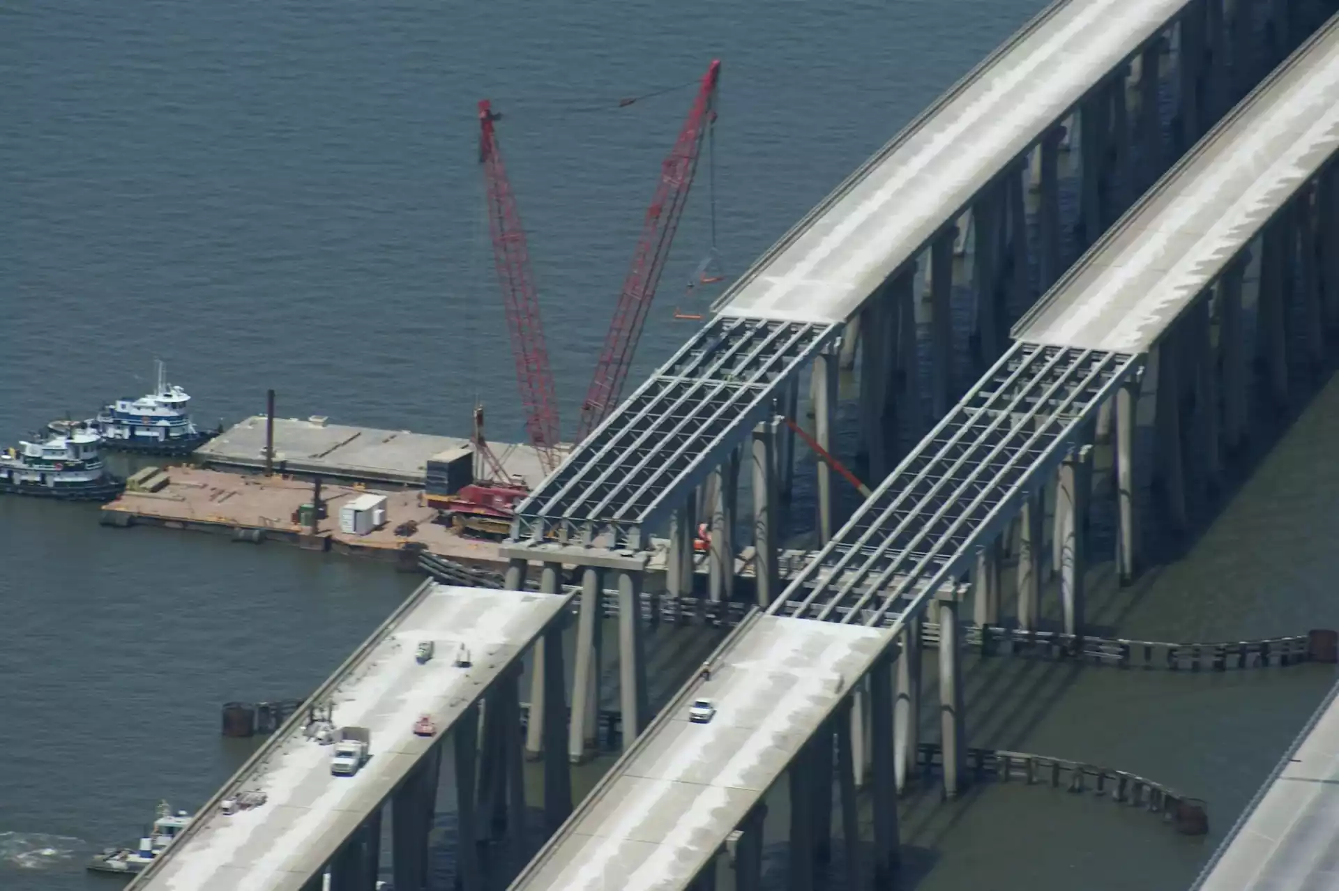
I talked to a civil engineer buddy of mine about why the photos of the construction look so chaotic. He pointed out that the new bridge was built just 300 feet east of the old one. Imagine trying to drive thousands of massive concrete piles into a lake while an active, shaky, "repaired" bridge is right next to you.
They used special sensors—vibration monitors and inclinometers—to make sure the construction of the new bridge didn't accidentally knock down the temporary one. If you see photos of barges with massive cranes (owned by the Traylor-Kiewit-Massman joint venture), that's the heavy lifting that saved the region's economy.
Actionable Tips for Your Visit
If you’re heading out to see the Twin Spans or take some shots, keep these things in mind:
- Check the Wind: Lake Pontchartrain is shallow. High winds make for "choppy" water which looks great in photos but makes the fishing pier a bit spray-heavy.
- Golden Hour is King: Because the bridge runs roughly North-South (well, Northeast-Southwest), the sun sets to the side of the bridge. This gives you incredible side-lighting on the concrete columns.
- Respect the History: Remember that for many people in Louisiana, these bridges are a symbol of recovery. The 2008 construction accident that claimed the life of worker Eric Blackmon is a sobering reminder that this "photo op" came at a high cost.
The I-10 Twin Span Bridge is more than just a way to get to the Northshore. It’s a 5.5-mile long testament to engineering resilience. Whether you're looking at archival disaster photos or the sleek lines of the 2026 commute, you’re looking at the backbone of New Orleans.
Next Steps for You:
If you're planning a photography trip, start at the St. Tammany Parish Fishing Pier in Slidell. It's free, has plenty of parking, and offers the most accessible "up-close" views of the architecture without needing a boat. Bring a tripod—the vibrations from the traffic on the new bridge can be felt even on the pier, and you'll need stability for those long-exposure night shots.